|
|
|
|
Ohinemuri River Historic Walkway - Discussion Document |
|
|
|
This is the initial document created April 2004. Ohinemuri River Historic WalkwayThis document discusses the Waihi to Waikino Walkway proposal. A Waihi Walkways initiative. The Vision An historic and scenic walkway linking Waihi and Waikino and the Karangahake Walkway. Of easy grade, and to Department of Conservation standards, this popular walkway retraces the water race and the rail link between Martha Mine and the Victoria Battery. Detailed interpretation encourages understanding and appreciation of the rich heritage of this area. The wonderful Ohinemuri River is experienced at close quarters, encouraging communion and contemplation. After years of neglect, the river is being restored to health by riparian plantings and sensitive restorative works. Clear, clean water, and enhanced fish and bird life are the visible rewards. This walkway is part of an extensive network of walkways, creating wonderful recreational and educational experiences for visitors and residents alike. The Route The Ohinemuri River Historic Walkway will connect Waihi with Waikino via a walking track on the true left bank of the Ohinemuri River. After crossing the river at the Waihi Dredging Plant site at the end of Lawrence Road in Waihi, the route would loosely follow the rakeline, water race, and river reserve downstream to the Victoria Battery site at Waikino (see map, page 5). The Heritage In 1897 the Waihi Gold Mining Company started erecting the Victoria Battery at Waikino to provide additional stamper capacity for the crushing of Martha ore. The battery started operating in 1898 with 100 stamps. The site at Waikino was chosen largely because of the water power available from the Ohinemuri and Waitekauri rivers. The low-pressure supply came from the masonry dam on the Ohinemuri River, built just below the confluence of the Waitete Stream in 1897. The water race was 12ft wide and 4 1/2ft deep and in the main consisted of a ground channel. The Ohinemuri River was bridged by two trestled flumes, and a 475 ft long siphon traversed a patch of swampy ground at about the mid point. The race had a fall of 54ft, driving the stamps through two turbines. Ore was hauled the five miles (8km) to the battery by steam locomotive along the 2ft 9in gauge tramline. Each locomotive hauled a load of 40 side-tipping ore filled trucks on the downhill gradient to Waikino. This configuration of loco and ore trucks was known as a "rake", and hence the tramway was generally called the "rake line". There was a loop in the tramline at the halfway mark to allow one locomotive hauling a full rake to pass the other locomotive returning to Waihi with an empty rake. The rake line crossed the Ohinemuri River just upstream from the masonry dam (and dredging plant) on a timber trestle bridge, known as Black Bridge. The tramline and bridge were also constructed 1897. The Waihi Dredging Plant was established in 1897 to reprocess tailings sucked from the Ohinemuri River. Much experimentation took place during the life of this plant, and of particular note is that air agitation tanks were invented and patented worldwide from this site by CF Brown. The Waihi Paeroa Gold Extraction Company purchased the plant in 1908, and after two years of successful operation, the plant was moved to Paeroa and incorporated into a very large plant being built at Mill Road. The heritage features accessed by the walkway include:
The Environment The environmental features accessed include:
Discussion The Dredging Plant is accessible via the end of Lawrence Road, from the parking area at Dean Crescent via an as yet unformed track beneath the railway bridge, or from Victoria Street via the proposed Victoria Walkway along the Ohinemuri River. Waihi Walkways is establishing a walkway link from Gilmour Reserve along the Ohinemuri to the Dredging site. Some form of river crossing is required to gain the opposite bank (true left bank). River reserve extends downstream until the last property before the battery. The reserve is for the most part navigable on foot, or could be made so. Both the rake line and water race occasionally impinge upon the river reserve, but for the greater part they cross private land. Both are wonderfully intact for much of the distance. Several small streams enter the Ohinemuri. These would no doubt have been captured by the water race when it was in use. Seven private landowners, Land Information New Zealand, and the Department of Conservation (Victoria Battery site) border the Ohinemuri along the proposed walkway. All the private land is farmed to the river’s edge. The LINZ land is largely covered with weed tree species, with stock grazing to the water’s edge. Most landowners have been spoken to in the past, and most of these responded favourably. Mapping and survey work has been started. The journey could be one way, with return possible on the Goldfields train. This would require formalising a link between the train station and the dredging site. This should not be difficult. Opportunities exist for restorative plantings, and riparian plantings. Flooding of the Ohinemuri and its tributaries is common, and must be considered, particularly with regard to structures and walker safety. The Options Ohinemuri River crossing by: suspension bridge, cable ferry (self-propelled), or flying fox. The walkway would follow either the riverbank (ie within the river reserve), the rakeline, the water race, or most likely a combination of all three. This requires the co-operation of the landowners, and perhaps some formal access agreements. Stream crossings require bridging where the walkway can not make use of farm crossings. In some areas a formal pathway would be required. This would need to be metalled, and some boxed steps may be required. In other areas a less formal approach could see wider areas of the grassed river reserve available to the walker. Kissing gates would allow continued grazing of the riverbank. The pathway could be formalised and metalled as traffic impact dictated. As no Department of Conservation land is involved, this walkway could collect a toll. Management and maintenance could be undertaken by Waihi Walkways, or by some other body. The Stake Holders
Support There is a high level of community support for this project. This document forms the initial liaison with all interested parties. A foot survey and mapping exercise is part of this initial proposal. Costs
Funding Funding agencies should look favourably on such a worthwhile and well-planned project as this. Funders could be:
Next Steps Below are some of the proposed next steps. Funding can be sought at each stage.
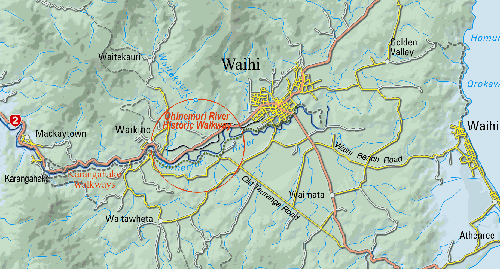
Location Map
Location map courtesy of Go Waihi, modified to show location and approximate route of the proposed Ohinemuri River Historic Walkway. Note also the walkways linking this walkway with Gilmour Reserve, Union Hill and Black Hill. Ultimately, walkways will link the Martha Lake area and Union Hill Heritage Area to the Victoria Battery and Karangahake Walkway at Waikino. oo000oo Back to Top
|
|
Waihi District Walkways Inc. PO Box 241 Waihi New Zealand Send e- mail to: Waihi Walkways |